--->
[Fieldworks]
Engineering Geological Fieldwork Cambrils (Spain, 2002)
This 5 week lasting fieldwork included:
- The mapping of the engineering geological units a given area to create an engineering geological map.
- A feasibility study for a windmill development and several structures in the mapped area.
- A slope stability investigation.
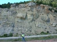
The engineering geological map covers an 12.75 square kilometers area around Pratdip, Province of Tarragona, Spain. Together with a student from Nepal, I studied the area for several weeks. The fieldwork included rock and soil classifications, mapping, sampling and exploring the engineering geological units within the study area. The result of this fieldwork, an engineering geological map (scale 1:10,000), contained apart from the different soil and rock units, important fracture and fault zone and geomorphological features, such as erosion gullies, seepage zones, rock falls, landslides, etc. The feasibiltity study was done after the fieldwork. The study had to be done alone. Information gathered during the creation of the engineering geological map together with several rock and soil test conducted near the fieldwork area and in the lab at the University were used.
The purpose of the stability investigation, requested by ITC & TUDelft, was to determine if the slope in question was unstable and if so, if the consultant and contractor who rebuild the road in 1989 could be blamed for the instability of the slope. To archive this, the slope stability study included: a study of the geology of the area, the determination of the geotechnical characteristics of the material encountered in the slope, an assessment of the stability of the slope, a design of the structure that would have been best possible at the time that the road was build, based on the reconstruction of the topography and geology, an assessment of the stability of the slope to investigate if the slope has been over blasted during the excavation in 1989 and finally an evaluation of the predictability of the weathering in places where instability is the reason of weathering. During the study several methods were used to assess the stability of the slope: the SSPC (Slope Stability Probability Classification) , the Kinematic analysis, a visual description of the conditions of the slope and a reconstruction of the old road cut through the assessment of the remaining sections
Geophycical Fieldwork Rotterdam (The Netherlands, 2002)
Application of numerous Geophysical mearsuring techniques, including resestivity profiling, Ground Penetrating Radar, Seismic Refraction, Electro Magnetics, etc..
Engineering Geological Fieldwork Green Mountain (Colorado 2001)
During my exchange program at CSM several interesting practicals were given. One of them was the Engineering Geological Fieldwork at Green Mountain. The purpose of this study was the evaluation of the feasibility of a construction of an extension o on the west side of Green Mountain, Jefferson Country, CO, USA. Together with the information obtained in the field different maps were created A topographic map, slope percent map, Unified Soil Classification map, GLQ map, landslide map, interpretative map, expansive soil map, drainage classification map, landslide hazard map and an engineering geologic map. Finally all the areas on Green mountain were classification for the relative suitability of construction taken into account the constraints and the geologic/environmental hazzards. .
Slope Stability investigation (Colorado 2001)
Another interesting practical given during my exchange program at CSM was the rock slope stability investigation of a rock slope along the Highway I-70 Between Idaho Springs and Denver. The rock slope was made up by metamorphic Precambrian rocks, called Idaho Springs Formation, containing gneiss and amphibolites and small and large intrusions containing pegmatite. The rock at the slope was moderate fractured to heavily fractured resulting in possible failure plains. The slope is half a mile long, reaches up to 30 foot in height and has a steep to vertical angle. To assess the stability of the slope a detailed horizontal scanline survey was undertaken. During this survey all discontinuities, that intersect a straight line along the slope (scanline), were recorded. The measurement values from the line survey and additional observations were processed with the software Stereo Net
Structural Geological Fieldwork Vesc (France, 2000)
The field work area, located in the South-East of France near the little village Vesc, consisted of approximately 50 square kilometres. The fieldwork took several weeks. Seven different Stratigrafic Formations were distinguished in the field which were deposited during the Jurassic and Cretaceous time period. Many geologic structures were identified including thrust faults in the western part dipping to the west and anticlines and synclines in the eastern part with E-W axis. Most of the geologic structures originated from the North South compression (Pyrenese phase) and East-West compression (Alpine phase).
Website: Jeroen van Nes, The Netherlands Update: 30 May 2005 Address: http://www.van-nes.nl/jeroen/ Information: jeroenvannes@hccnet.nl